Google Launches App For Indoor Venue Mapping
by 6 April, 2012 10:00 am0
Sometimes it’s just hard to figure out where you are, especially when you’re inside a huge mall or stadium for the first time. Traditional paper maps and building directories are usually of no help either, they don’t actively track your current location.
What if there was a better solution? What if you could figure out exactly where you where inside an amusement park, or a shopping mall, without having to fret around with a bulky paper map?
Indoor Venue Mapping
 Several of the big name map providers (Google Maps, and Bing Maps, etc.) have begun adding indoor venue maps to their existing map services. Most of the indoor venues that have already been mapped are large scale structures like airports, shopping malls, convention centers and sports stadiums.
A lot of the large venues have been added to map services thanks to direct support from the actual venue, who specifically aided by providing data in the form of blueprints, and by using mapping software. But not all venues are able to lend support when indoor mapping is concerned, which leaves map providers like Google and Microsoft to figure out alternate ways of mapping indoor locations.
Unfortunately, it’s hard for a service that uses wireless signals to directly pinpoint where a subject is in relation to an enclosed space – even with structure blueprints. GPS doesn’t work well in a lot of enclosed areas, and Wi-Fi access points are only relevant where their signal reaches. Obviously cell phone towers aren’t reliable when indoors either, especially considering most reception starts to die off when a mobile device is located in an enclosed space.

Google Maps Floor Plan Marker Indoor Venue Mapping Application
Google aims to change the indoor venue mapping game with the release of a mobile app that runs on any Android 2.3 (and up) powered device.
The application, called the Google Maps Floor Plan Marker, is available via Google Play.
Once installed, the app will begin to collect data about various venues and structures which will be used to better measure a user’s indoor location. The application will specifically improve indoor venue mapping techniques by measuring the surrounding environment; the app will locate nearby Wi-Fi hotspots and take into account cell phone tower positions.
The app encourages users to map the inside of a location using various techniques, and as you can see from the related image most of those methods generally include surveying the location by walking through it.
As mentioned on the indoor venue mapping app page, Google is currently interested in locating a user’s floor location – which basically means they’re trying to accurately measure what floor a user is on. This is certainly relevant as it will properly update a user’s map image, as most venues have varying layouts for each level or floor.
Currently the Google Floor Plan app is only available for users who have previously uploaded a venue floor plan. Anyone interested in using the app, should upload a floor plan to Google’s floor plan page.
Hopefully Google will eventually allow everyone who owns an Android device to use the indoor venue mapping app, it would certainly help improve the Google Maps service and would ultimately work in their favor.
Google Maps 6.0 Indoor Venue Mapping Update
Thanks to the release of Google Maps version 6.0 users are now able to pinpoint their location while looking at an indoor map of select venues.
Google made the original announcement about the Google Maps upgrade back in November, 2011 on their official blog. In the related post Google further elaborated on the indoor mapping features of the new Maps version:

“When you’re inside an airport, shopping mall or retail store, a common way to figure out where you are is to look for a freestanding map directory or ask an employee for help. Starting today, with the release of Google Maps 6.0 for Android, that directory is brought to the palm of your hands, helping you determine where you are, what floor you’re on, and where to go indoors.”
“Detailed floor plans automatically appear when you’re viewing the map and zoomed in on a building where indoor map data is available. The familiar “blue dot” icon indicates your location within several meters, and when you move up or down a level in a building with multiple floors, the interface will automatically update to display which floor you’re on. All this is achieved by using an approach similar to that of ‘My Location’ for outdoor spaces, but fine tuned for indoors.”
In order to provide indoor maps and indoor user locations Google has partnered with various retailers, airports and transit stations like the Mall of America, and the San Francisco International Airport. Of course, there’s plenty more venues Google has partnered with to improve the indoor mapping features of Google Maps – for a more extensive list see the official blog.
Hopefully the new new indoor venue mapping app will work to expand the use of location services as Google intends, it certainly opens up plenty of new opportunities.
Here’s some more images of the Google indoor venue mapping app in action – because we’re cool like that.


Readers may also be interested in checking out: The Top 5 Must Have Apps for Designers
Related posts

iPhone / by - ago
iPhone 17 Price and Availability
Stay ahead of the curve with the most anticipated iPhone 17 Price release, offering unparalleled innovation, including advanced A19 Pro chips, enhanced camera capabilities, and sleek redesigns, making the new iPhone 17 series a must-have at the right iPhone 17 Price.
iPhone / by - ago
Why You Should Upgrade to iPhone 17
Discover why the iPhone 17 is worth the upgrade — from cutting-edge AI and improved battery life to a stunning new design. Here’s everything you need to know…

iPhone / by - 1 August, 2025 8:37 am
Latest iPhone 17 Rumors
Discover the exciting possibilities of the next-generation iPhone, as we delve into iPhone 17 rumors surrounding new colors, storage options, and innovative features that could revolutionize the way you interact with your phone…

iPhone / by - 29 July, 2025 5:47 am
How to Preorder iPhone 17
Stay ahead of the curve with the iPhone 17 preorder, anticipated to start in September 2025, and discover the cutting-edge technology and sleek designs that are coming your way…

iPhone / by - 25 July, 2025 8:12 am
iPhone 17 Release Date, Features, and Specs
The iPhone 17 is just around the corner, and we’ve got the inside scoop on what to expect from this highly anticipated device. Stay tuned for updates on features, pricing, and more!

Announcements & News / by - 15 February, 2016 4:36 am
ICANN to Allow .What-everrrr Domain Registrations
The Internet Corporation for Assigned Names and Numbers (ICANN) has changed a rule that will allow the reservation of existing domain names that use any combination of letters and numbers….
Latest / by - 4 February, 2016 1:04 pm
Some of the more popular alternatives to point of sale checkout
Decades ago we were all used to queueing at the traditional point of sales (POS). The high street cash register was king when it came to paying for purchases, in…
iPhone / by - 19 January, 2016 2:47 pm
How much protection do you get from an iPhone screen protector?
Many people argue that it’s no longer necessary to protect your iPhone with a screen protector due to the higher quality of glass used in construction. If you have seen…
Tech News / by - 4 December, 2015 4:30 am
Why Would I Need a GoPro?
While modern smartphone cameras have moved far beyond their basic beginnings to become comparable alternatives to dedicated camera equipment for amateur photographers, the GoPro’s range of advanced features make it…

Tech News / by - 11 September, 2015 6:20 am
Here’s Why You Should Buy a Tablet This Year
The iPad was introduced in the spring of 2010. That was the beginning of the modern tablet era. In fact, 2011 was the year of the iPad/tablet. From that point,…

Tech News / by - 18 June, 2015 11:06 am
Smart Decisions to Secure Your Apple Device
Millions of customers use iPhones, Macbooks and other Apple devices. The growing use of Apple products has led to hundreds of security threats to these devices. Malware and viruses can…

Tech News / by - 5 March, 2015 4:42 am
How Economic Networks Are Replacing Economies of Scale in The Knowledge Economy
In the book, Information Rules, authors Carl Shapiro and Hal R. Varian make an astonishing statement: “There is a central difference between the old and new economies: the old industrial…

Tech News / by - 9 December, 2014 6:59 am
Samsung Galaxy Products: A Cut Above The Rest
Samsung is the market leader in terms of smartphone sales. Samsung galaxy products are ahead of its class and are known for its innovative features and affordable price. The company’s…
Tech News / by - 20 November, 2014 8:29 am
Japan’s Domestic Companies Loss is International Online Casino Industries Gain
Japan remains one of the largest, if not the largest, untapped gambling markets in the world, in regards to both the online and offline sectors for domestic companies. This dominating…
Tech News / by - 7 November, 2014 5:57 am
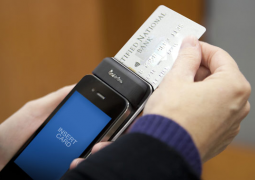
Five Reasons to Use Your Smartphone as a Credit Card Reader
Years ago, the term “credit card reader” was not used very loosely. Either you had a machine that allowed you to take an imprint of a customer’s credit card or…

Tech News / by - 9 July, 2014 9:35 am
More Creative Ways to Sell Your Products Online
Selling goods on the Internet is both easy and difficult. It’s easy because there are many available resources that make setting up online shops quick and easy. They can also…
Tech News / by - 9 July, 2014 9:25 am
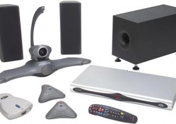
Getting the Right Video Conferencing Equipment for an Effective Team Collaboration
Any time you need to get on a video conference call, you might worry about whether the person on the other end can see and hear you properly. If you’re…

Tech News / by - 23 May, 2014 6:09 am
Fighting Internet Lag – 4 Strong Tips For Reducing Connection Latency
Internet drag, or “latency” is a dreaded occurrence to all equally. It sucks to have to wait for buffering, or to have your immersive video gaming experience so rudely interrupted…

Tech News / by - 5 August, 2013 7:28 am
When Tech Goes Wrong – The Biggest Tech Outages of 2013
Most of the time, we expect search engines, social networks and other forms of web technology to be up and running – but recent events have shown that even big…

Tech News / by - 20 July, 2013 2:26 pm
New Apps You Must Know About
Combining Apps with IFTTT iPhone’s new automation app ‘If This Then That’(IFTTT) allows you to bring two separate apps together by mentioning which of them is the “This” one and…


